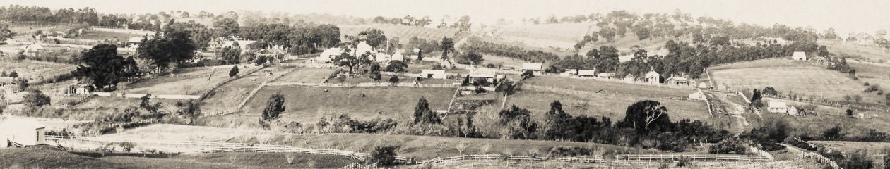
MYSTERY SOLVED – looking eastwards across the Watsonia Drain and along Lower Plenty Road at a point just opposite Bannockburn Road (on the right, out of view). The main direction of sight is looking down the new alignment for Lower Plenty Road where a bulldozer is clearing for its construction towards the new Lower Plenty Bridge.
#MysteryMonday – Today’s image is of a rural highway scene, most likely within the former Shire of Eltham. It has been digitised from a single frame of medium format 6 x 6 negative so no surrounding images to help identify or date. But it is believed to be mid 1960s. The scene depicts a rural highway sweeping around to the right as it crosses a creek running from left to right.

There is a house in the upper centre of the image and just behind the house to the upper left can be seen a high voltage transmission tower. In those days, the only transmission lines in the shire were running through the Lower Plenty district. The transmission lines running north through Research and northwest were yet to be constructed so that should assist in identification.
Can you solve the mystery and help us to catalogue this image?
Over to you . . .

Hmmm…my thinking is of two possible places…one is the Main road which winds over the Diamond Creek ..it goes past the now Miniature Railway and Park on the right and there was eventually a market garden on left and a general store…OR it’s perhaps somewhere in the Rosehill road area…best I can do at this moment!!
LikeLike
OR…thinking on it..is it somewhere near the Lower Plenty Hotel…there were those transmission lines there but I never knew what the ‘creek’ was..always thought it was a river…we used to come home that way when I was VERY little – a treat to go into the Queen Vic market…and Dad would always stop just for the one at the pub…the approach then on the left would later become the Yallambie estate…
LikeLike
Hi Robyn, definitely not the first thought; the power lines eliminate that. Our initial thoughts were Lower Plenty also but the bridge was all wrong for Lower Plenty Bridge. Turns out we should have been looking a bit further west in an easterly direction as Lower Plenty Road crosses the Watsonia Drain – see our comment re Mystery Solved
LikeLike
l think the photo is taken from the corner of lower plenty and Yallambie rd ,it looks like they are getting it ready to straiten lower plenty rd by the fences and bull dozer in the paddock
LikeLike
I have no idea where it was taken but can’t stop looking at it to figure it out. The bridge in Henty is one lane so it might not be the right one. The Lower Plenty pub was down low right at the road. What about the end of Martins Lane? I don’t think the angle is sharp enough. Thinking outside the square, it reminds me of Porter St Templestowe, coming down the hill from Templestowe. I don’t know where the power lines come from before Rosehill Rd. It might be the one on the hill. I’ll keep looking! One thing, at the time the Main Roads around here were just like that one. Many roads were still dirt
LikeLike
MYSTERY SOLVED – Robyn Youlten and Nick Redpath; along with several other well informed folk on Facebook have correctly identified the mystery. The view in question is looking eastwards across the Watsonia Drain and along Lower Plenty Road at a point just opposite Bannockburn Road (on the right, out of view). The main direction of sight is looking down the new alignment for Lower Plenty Road as clearing has commenced for its construction towards the new Lower Plenty Bridge. Google Street View today presents a very different outlook.
LikeLike